Governor's Palace Stable Architectural Report, Block 20 Building 4Originally entitled: "A Proposal for the Governor's Palace Stables Based on New Evidence"
Colonial Williamsburg Foundation Library
Research Report Series - 1472
Colonial Williamsburg Foundation
Library
Williamsburg, Virginia
1990
A PROPOSAL FOR THE, GOVERNOR'S PALACE STABLES BASED ON NEW EVIDENCE
I Review of Previous Evidence and Conclusions
After making numerous studies for a possible form and location for the stables, a report was read by Perry, Shaw and Hepburn before the Advisory Committee of Architects at its meeting in Williamsburg November 16, 1933. Subsequent to a full discussion, the following action was taken by the committee:
"Vote No. 1
Palace Stable:
On motion by Mr. Kimball, seconded by Mr. Tallmadge, it was VOTED RESOLVED that saving the discovery of further evidence, there should not be built a Governor's Stable."
On December 22, 1933, Mr. Arthur Shurcliff made a preliminary report explaining his belief that the stables should be located along the east line of the Palace grounds somewhat south of the mid-point. (East of 22 and 24 on illustration A)
Thus the matter lay for sometime until Mr. Shurcliff made a more detailed report, May 5, 1938, reviewing and adding to his theory of December 22, 1933. On June 17, 1938, the Architectural Department issued a reply by Messrs. Kendrew and Moorehead and on July 1, 1938, the Research Department added its comment by Mrs. Bullock. As a result of these replies further consideration of the problem ceased, pending the appearance of new evidence.
II New Evidence
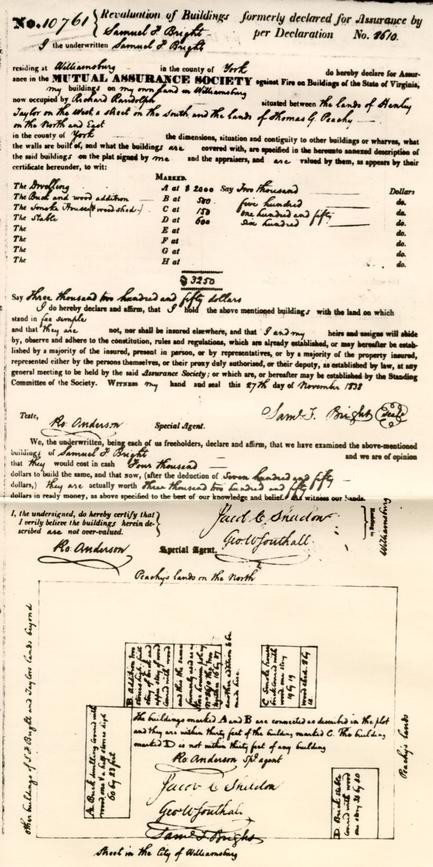
Recently the Research Department found two 19th century insurance policies dated respectively December 27, 1837 and November 27, 1838, both made out for Samuel F. Bright and both showing a brick stable in what was formerly the south east corner of the Palace grounds. (See appendix) This discovery shed new light on what admittedly had become a somewhat frayed subject and brought about a thorough review of the whole question.
Another interesting item was also found which speaks of Botetourt's coach standing in a building near the Palace as mentioned by Timothy Pickering September 9-16, 1781. (See appendix)
Another bit of evidence is the list of expenditures for repairs to the Palace from the Executive Journals of the Council- Mss. Virginia 2 State Library. Most of these entries are new to us. A partial and condensed listing is as follows:
| [For fiscal year ending] | |
| April 1760 | 115:3:5 |
| April 1761 | 146:10:5 |
| April 1762 | 127:6:3 |
| April 1763 | 136:7:4 |
| (1764-67 are missing) | |
| April 1768 | 440:1 |
| April 1769 | 596:14:7 |
| October 1769 to April 1770 ( ½ year) | 312:17:9 |
The significance of these figures will be mentioned later.
Except for the period of rehabilitation in the 1750's the entries before 1760 were of lesser quantity on the whole although a few were slightly greater.
Terms of office of certain Governors for reference with the above schedule:
| Dinwiddie | November 20,1751 | To June 7, 1758 |
| Fauquier | June 7, 1758 | To March 3, 1768 |
| Botetourt | October 28,1768 | To October 15, 1771 |
| Dunmore | August 1771 | Fled from Palace June, 1775 |
III New Conclusions
All along there have been five possibilities for the location of the Stables. Some were obviously voided by negative evidence while the others presented distinct possibilities. However, none of the more favorable schemes were sufficiently supported by fact to render them feasible for actual reconstruction.
With the new evidence at hand each of the five possibilities was again reviewed since former conclusions were illuminated by the light of the new evidence. Many considerations formerly rather hazy now became more distinct. The effects of the new illumination can now be listed as follows:
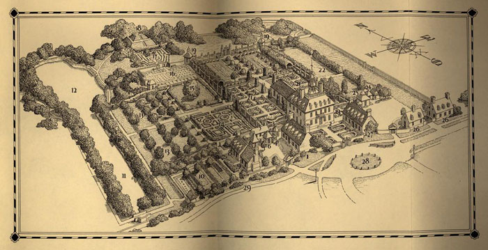
(See illustration A and numbers thereon)
1 Southwest Corner — 8, 9, 10
This area is ruled out as a stable location because of its known use for kitchen services and the existence of the terraces.
2 Northwest Corner — 16
As far as space is concerned there in ample room here for a stable group which would provide accommodations for the horses, vehicles, equipment and personnel listed in the Fauquier, Botetourt or Dunmore inventories. In order to determine this, a series of possible layouts were studied in sketch form from which one scheme was selected as the most favorable. It is not attached to this report because of the rather conclusive reasons against it as itemized below:
- aThe ground level of 16 is about 8' below that of the graveyard at 15. It would be expected if 16 were occupied by stables that some means would be taken to divide 15 and 16 in order to keep the horses out of the garden areas. The normal method of accomplishing this would be to provide a wall of necessary height but no evidence of this was found. In fact, original steps and terrace contours were discovered which, quite justifiably, have been restored along this line thus ruling out a wall completely.
- bAnother serious count against the possible scheme arises from the consideration of access for stable use. It would appear logical that the access would have been through the gate at 1 via 14 and 15. But the difference in grades just mentioned, the known use of the kitchen yard and its outbuildings and the negative evidence in original path locations at 15 preclude this assumption. On the other hand, it would seem illogical to provide access at 16-17 because traffic to it would cross the main axis 19-19 and would be very circuitous, to say the least. In all the Virginia and English places studied no example of such crossing of the main axis was found. Indeed, in the meeting of the Advisory Committee of Architects mentioned under I, this fact was emphatically stressed and was considered absolute.
Before leaving this location the fact that a large building is shown here an the Frenchman's Map must be explained. From further review of the military activities at the Palace during the Revolutionary War, which were considerable, it would appear quite possible that the structure served a military purpose and was not, therefore, one of the Palace outbuildings.
3 Northeast Corner — East of 19
We have no definite information to prove that the stables were or were not located here. We do know that the general area 19-22 and east thereof was graded by the C and O Railroad some years ago which accounts for the fact that no foundations were uncovered during our archaeological investigations.
As a logical site this location has much in its favor. It would be easily accessible from the Governor's Park and from the road shown on 4 the Frenchman's Map and now restored northward via the gate at 26-26. It would be at a distance from the Palace proper — a characteristic of stable locations on Virginia plantations.
In lieu of more positive evidence we are forced at this time to dismiss this possibility which, to be frank, we do with much reluctance.
4 Near Location Under 3, but Outside the Palace Grounds
Another favored site. The comment under 3 applies equally to it.
5 Southeast Corner - 26-26
The Brick Quarter
The treatment of this area as now reconstructed was based on fragmentary foundations uncovered during the archaeological survey, the Frenchman's Map and the June 2, 1790 record of the sale of former Palace property by the College of William and Mary. In this deed the area is referred to as follows: "… Beginning at the Southeast corner of the Palace Brick Quarter…" Lacking any other direct evidence of the character of the structures believed to have occupied this corner, the term "Brick Quarter" loosed large and was interpreted as may now be seen in actual construction. On second thought, however, the term does not rule out the presence of stables.
The Insurance Policies
If we turn to the two insurance policies, (see appendix) a discrepancy appears in the overall dimensions of the stable. The December 1837 policy shows the stable as brick covered with wood 36 x 32 [feet]. The November, 1838 policy shows it of the same material but 34 x 40 [feet]. But such variations have been noted in other instances in early Williamsburg policies. The larger of the two was selected for consideration.
The Inventories
From the inventories it appears that Fauquier had three vehicles and eight horses; Botetourt, four vehicles and ten horses; and Dunmore four vehicles and seventeen horses of which four were colts. The latter undoubtedly kept some of his horses and vehicles at his Porto Bello property but the extent of this division in not known.
The Schedule of Cost of Repairs to the Governor's House
A reading of this list and comparison with the terms of office, (see under New Evidence) indicates that during the time of Botetourt the expenses increased very greatly. Previous to him they were much more 5 modest. It is possible that extensive repairs or redecorations were undertaken but these are not reflected elsewhere in the research notes. When it is considered that the number of horses and vehicles also increased under Botetourt a clue may be at hand for the swelling expenditures, part of which might have been devoted to increased stable and vehicle facilities.
The Pickering Comment
Also listed under New Evidence is the Pickering Comment about the state coach in a building near the Palace. (See appendix)
Plans and Elevations of the Stable and Coach Houses
Referring again to illustration A, it is proposed that the present buildings 26-26 (from left to right be replaced by a coach house and stable respectively and that a single structure to contain the state coach be constructed a short distance north of the stable - see drawings 1, 2, 3, 4, 5. As can be seen in plan, the demands of the Botetourt inventory for accommodation of horses and vehicles would be satisfied as well as for harness and personnel.
The Stable
Of several schemes studied the plan as shown in the most logical. In it are accommodations for ten horses, feed boxes, harness room or storage, Groom's and Coachman's Rooms with their fireplaces as mentioned in the Botetourt inventory. Typical precedent from early stables at Mt. Vernon, Mt. Airy, Shirley, Stratford, King William Court House, Port Royal and the old Inn at Gloucester Court House will be used for the building form as well as exterior and interior details. Overall dimensions follow the insurance policy of 1838. The gable forms are similar to the Stratford Stable and may be seen in Williamsburg at Tarpley's Store, Brick House Tavern and Dr. Barraud's House.
As the scheme was developed a possibility suggested itself that what is shown as the stall area may represent an earlier stable to which was later added the part containing the spaces for harness and personnel. If such a change occurred, a complete revision to the roof would have taken place as Well. The fenestration expresses this change and, it is felt, makes more convincing the north and south elevations. Also this interpretation would account for some of Botetourt's expanding expenses.
It is proposed for purposes of operations, that the second floor not be an exhibition space but arranged as shown on drawing #4 with a work room, locker room and bedroom. Indeed, the State Fire Code forces this upon us if personnel is to be housed on this floor.
The Coach House
Evidence for the reconstruction of this building as it stands 6 was based partly on original foundations which indicated location and width and the Frenchman's Map for length. This evidence would still apply but instead of a structure devoted to living quarters, as now, it is proposed to make the building a coach house to contain three large vehicles or more smaller ones. As in the case of the stable the same general precedent would assist us in the design. It would retain the same construction with the south wall of brick and the others of frame. It would also be a logical explanation of expanding stable needs in colonial times.
The State Coach House
By providing a special small building, the state coach can be housed. The Pickering comment suggests this possibility — see under New Evidence. We have good precedent for such a structure at Mt. Vernon and the Joshua Frye place in Albemarle County. Here again is a visible explanation of expanding stable needs.
Some General Considerations
The proposal indicates the belief that the stables were enlarged in Botetourt's time and that the reference in the deed of sale in 1790 by the College of William and Mary to the "Brick Quarter" does not preclude the presence of stables in the south-east corner of the Palace grounds. Further, that the building referred to in the insurance policy of 1838 was one of the old Palace stable structures. It is possible, of course, that this was not so and that the stable had disappeared by 1838. Our only clue, at the present time, to the fact that it remained is Mr. Charles' recollection of it. He locates it as shown on the insurance policy and identifies it as "… evidently once being a part of the Palace equipment."
By: S. P Moorehead March 9, 1950
Sept. 9-16, 1781.
…
In a building near the palace are to be seen the remains of the richly ornamented state coach, which was brought over with Lord Botetourt, and once used by him to carry him from the palace to the Capitol. 'Tis a clumsy machine,, and enormously heavy,-perhaps equal to two common wagons. It is gilded in every part, even the edges of the tires of the wheels. The arms of Virginia are painted on every side. The motto of the arms led me to remark how peculiarly disposed the Virginians have been to adopt ideas of royalty and magnificence… The motto is, En dat Virginia quartam, --that is, 'Virginia gives a fourth quarter to the world.' …
January 12, 1932
Perry, Shaw & HepburnAttention: Mr. Thomas M. Shaw
131 Milk Street
Boston, Mass.
Dear Mr. Shaw:
Mr. Herbert Ragland just drew my attention to a new development which is just becoming apparent in the course of his excavation of the Palace stable. This is a three foot projection out from the walls' face on both the west and north sides of the stable foundations. This projection is about twenty-four feet long. Its location is shown on the accompanying tracing which Mr. Ragland just made for me.
Mr. Ragland's theory, which I feel is worth while thinking over, is that possibly this represents some sort of a formal gateway or "sally port" which gave entrance on these two sides to the inner court of the stable. Probably with a big arch. And undoubtedly treated as an architectural feature. Mr. Ragland also feels that the large size of the stable, not only as indicated by the length of the thing as it develops but also by its possession of such architectural features as mentioned above, would almost surely mean that there was a considerable amount of room on the second floor. Such room might have been used for lodging the servants, which would solve the question which may have vexed you a little bit as to whether such people were lodged in the Palace itself or in the Palace outbuildings.
Very truly yours,
Harold R. Shurtleff
HRS:mrm
cc:P.S.& H-Wmsb.
PALACE STABLE
[read at Nov. 16-17, 1933 meeting of Advisory committee of Architects ?]
[1] If we assume from the presence of stable and coach-house items in the Palace inventory, and from the 18th century precedent in both England and Virginia of grouping stables with the house, that the Palace stable was near the Palace, there is then only one place where the stable could have been.
[2] There are four corners-noted on the accompanying plan as A,B,C and D--to the Palace rectangle that is formed on the south by the line across the south end of the flanking buildings, on the north by the north end of the Palace gardens, on the east by the easternmost boundary as shown by documentary evidence, and on the west by the edge of the slope toward the canal.
This rectangle is further defined by the foundations found at three of the four corners. Any other place than one of these corners as a site for the stable-such as the area between the corners-would be impossible for self evidence reasons, except along the eastern boundary, and there the whole area between the southeast corner and the northeast corner has been excavated without any trace of foundations being found. Aside from that, the tendency toward some sort of symmetry in Virginia layouts would preclude the stable being between these two corners.
[3] At first the foundations at the northwest corner (near A) were thought to be these of the stable. The building shown here on the Frenchman's Map seemed to be of the size to justify this assumption. However, as the opportunity occurred for closer investigation it seemed evident that whatever these foundations were, they were not the foundations of the stable. In addition to this cogent reason for abandoning this corner as the stable site, there was the additional argument that a stable site on this northwest corner would be open to the criticism that it offended a canon of Georgian architectural design, which is that a stable should be so planed that access to it did not cross the axis of a vista.
2Next, the southwest corner (B) was considered as a possible site.
This proved to be untenable both because of the documentary evidence as to kitchens, laundry, smokehouse, etc., being there and because of the character of the excavated foundations which seemed to agree with the documentary evidence just mentioned as to the uses of the buildings that formerly stood there.
Then the southeast corner was considered. These buildings, however, as shown on the Frenchman's Map, are not big enough for the stable, and what is more are referred to as the "Brick Quarter" in the 1790 survey of the Palace lands (page 295 of Palace notes) which means that they wee used as servants' quarters. This precludes their being stables or coach-houses.
Therefore, by a process of elimination, the northwest corner seems to be left as the only possible stable site. Is there anything that would show that the stable could not have been there?
[4] In order to answer this question properly we ought to go over the whole archaeological and property line situation as far as this general eastern area is concerned.
First, it should be noted that the stable could not have been to the east of this eastern Palace boundary line shown on the plan as C-D, (at least until one approaches D) because our records show that the Palace property never extended beyond this line until it got up to the point marked E, at which point it ran in a line a little north of east, which was the beginning of the south boundary (E-F) of the Palace pasture. In the second place, as noted above, the whole area in between the two corners C and D within the Palace property has been excavated and nothing has been found there, except remnants of drains. In the third place, these drains that have been found are about midway on this boundary and close to and paralleling the boundary, and lead toward the northeast corner. In the fourth place, in grading operations some 3 years ago the soil around the northeast corner itself was removed to a point below where the old foundation could have been found if they had existed, and therefore if there had been a building there no evidence of it would have remained.
Therefore three of the above points (the other point shows nothing that is in itself convincing) would go to show that nothing of a physical nature exists that would prove that the stable was not in this northeast corner, except for what might seem to be the rather remote possibility of its having been on the present site of the Sinclair Oil Company tanks, which is marked X on the plan. I say "remote possibility" because such a site would be more unsymmetrical than would seem reasonable in a situation which gave no reason for such dissymmetry.
[5] We can not take up the positive points which, taken with the preceding, might, as circumstantial evidence, show that there is reasonable ground for believing that the stable was in the northeast corner.
- (A)It would be granted that a reasonable place for a Virginia stable of the 18th century would be where it would be easy to get the horses to water and easy to put them in pasture, which latter practice was general in Virginia. This northeast corner would be wall adapted for this (and better adapted than any of the other corners for this purpose) because it stands on the edge of what was the Palace pasture and is closer to a Good watering place than any of the others.
- (B) Mr. George Coleman remembers as a boy a place in the vicinity of this northeast corner that was called the "Palace pasture bars" or "gates". This point was somewhere in the circle marked on the plan. A site near the pasture gates would be a natural one for a stable.
- (C) Mr. Coleman also remembers as a boy some old 80"-wide foundations running east and west at a point somewhere in the circle noted above, which must have disappeared when the grading mentioned above was done.
HRS:mrm
PERRY, SHAW & HEPBURN
PALACE STABLES
June 17, 1938
Further considerations regarding the location along the East Boundary
We have read Mr. Shurcliff's interesting theory on the development of a stable group along the east wall of the square embracing the formal arrangement of the Governor's Palace. We have been asked by Mr. Chorley to contribute all facts in our possession which might be of interest regarding the theory, in cooperation with the Department of Research and Record.
We find that many significant items of documentary evidence need to be quoted, that specific reference be made tot eh definite archaeological evidence and knowledge involved in the area under discussion and that the results of many months of study and some fifty sketches be mentioned of the possible shape and size of the stables from the evidence of the inventories. In so doing, we are led to the conclusion, rather directly, that wherever the stables may have been, the evidence for their position as assumed by Mr. Shurcliff's theory is the weakest of the several possibilities, unless we are content to restore a large group of buildings on the basis of assumptive evidence.
In all the work of restoring exhibition buildings and layouts in Williamsburg, the results of careful archaeological study came first as supporting evidence. The Frenchman's plat and other maps and documents have been considered as supporting evidence only when borne out by the excavated evidence. At the Governor's Palace itself very definite discrepancies existed in the specifications, maps and drawings. the foundations presented clear evidence, however, and upon this more than any other was the building restored. To have erected this mansion on the basis of the documentary evidence without regard for the archaeological data, we would have today a different solution and a building of another size and appearance.
As a case in point, let us consider the Raleigh Tavern layout. Here, recently, with a careful study based on all known evidence we have arrived at a truthful representation on paper of the original group and grounds. Comparing this with what was erected, in no sense critically either of the present design or reasons for it, one can readily see the unwisdom of making a restored layout on an assumptive basis. It may only mean, as at the Raleigh, that sooner of later at great expense, readjustment, and labor, a revision has to be made to bring the whole scheme into line with the truth.
The stable group at the Palace was large. Were it put within the formal square, that spot or corner would overwhelm everything but the main building. The research already performed in the study and sketches just mentioned soundly and rightly proves this. Under these circumstance it is easy to see the expense involved in construction, heating, furnishing, revisions to present planting, new planting, paving, etc. and miscellaneous equipment. If placed according to an assumptive theory, such an outlay of effort and cost would seem to us unwise and unsafe. Furthermore, it is an unpleasant thought to consider the thousands 2 of visitors who would carry away a false impression, just as so many have at the Raleigh. We see, then, that in the long run it is more economical and reasonable to restore as truthfully as possible and that assumptive restoration may lead to an untrue representation of the facts to the visitor.
A large part of the assumptive theory is developed on the basis of English precedent. The precedent described has to do with 16th, 17th and even 18th century examples in illustrated form of country estates; from over one hundred illustrations available for consultation, some four have been selected as indicative of points favored in the theory. As we have found in reviewing such illustrative data, it is possible to select four or more prints to lend authority to any position theory for a stable within or without the Palace grounds.
The examples consulted, mentioned above, have to do with a certain mode of English life. Most authorities on architectural history agree that climate is the greatest single factor in shaping the art in its varied forms. As soon as Englishmen commenced practicing this art in Virginia, climate applied its modifying restrictions. Where kitchens and services were attached to the living quarters at home, they became severed therefrom and gradually, as separated units, developed into the "Virginia manner" of layout, as typical for the small farm or town house group as for the great plantations and estates - but in all cases noticeably different from the English manner.
A great, if not the greatest, 17th century layout in the colonies was Greenspring, near Jamestown, Virginia, which grew to be the imposing mansion of Governor Berkeley and the elaborate seat of authority. Here was see the separation of the units of service, so different from the English layouts built at the same time and later. Greenspring was in full flower after the middle of the 17th century. The services and conveniences are separated, the majority being grouped in a symmetrical manner with the larger units such as barns, and stables, set at the extremities of the scheme and outside the formal grouping. Here we have native precedent. There is no need to look far afield for it. Further, it is on a grand scale, so grand, in fact, that the whole square of the Palace grounds is but one-third of it in width and one-fourth in length. There are five buildings at the Palace while at Greenspring fourteen are shown, at the same scale on the same map. Noting this imposing scheme, one can hardly disregard it as conventional precedent for the comparatively small and later group of the Williamsburg governor's house.
The kitchen is the most important service in a house. Wherever possible it is kept within the master's unit. Centuries of convention dictated this to the 17th century Englishman. Yet he broke with his traditional precedent whom he built in Virginia. It is not in the least surprising when consideration is given the climate to see him move his stables also away from his house, pleasure gardens and more important dependencies. In New England it may well have been that barnyard odors were tolerated, but all evidence in early Virginia points to a quite different convention in tests.
3We have seem that by 1660 the "Virginia manner" was dispersing the outbuildings and dependencies. If we examine some of the great layouts here, where the original stable sites are known, we note significant facts bearing out our remarks:
| Place | Approximate Distance in ft. from main house | Remarks |
|---|---|---|
| Westover | 350 | Away from formal planting and separate from formal dependency grouping |
| Shirley | 450 | " |
| *Stratford | 325 | " |
| Mount Airy | 600 | " |
| Mount Vernon | 350 | " |
| Tryon's Place Wilmington, N.C. | Here the large governor's palace of the 18th century had its stables entirely off the formal grounds. The use of the flanking buildings, so like those at Williamsburg, was for offices. |
| Raleigh Tavern | 600 feet | Entirely away from whole layout and dependencies |
| Peyton Randolph | 600 " | " |
| Semple House | 200 " | At extremity of layout |
| Paradise House | 250 " | " |
| Pitt-Dixon House | 250 " | " |
| Prentis House | 250 " | " |
In the 18th century Smithfield, Portsmouth, Norfolk, Suffolk, Petersburg, Fredericksburg, and Williamsburg, the stable was at the back of the let, the deeper the lot the greater distance from the main house to it. In those instances when possible, as at the Peyton Randolph House and the Raleigh Tavern, the stable was two blocks away - at the edge of the town.
Surely, this mass of evidence bears out our statement that the Virginia convention was to keep stables away from the house, other dependencies and outside of the formal grouping of areas or divisions.
The archaeological evidence is simple, direct and negative for a stable location in the east central yard or area of the Palace grounds. The are in question was excavated with great care. As in no other portion of the Palace layout, very little material was uncovered, and the area was found almost totally 4 undisturbed. After removing the usual thickness of top soil, a large flat area of "hard pan" was exposed. All this was cleaned thoroughly. Diagonally, and about one line with the main building and "bannio" a drain was found leading to the ravine at the east. The original brickwork had been removed except in an area near the Bannio (present comfort station) and well. The trace of the missing portion in the otherwise undisturbed clay was clearly apparent and filled with debris. This trace was very significant because it cut directly across the stable position of the assumptive theory. If there were walls of buildings, sheds, etc. along the east line, why is it that neither the foundations themselves nor their trace in the clay were found? Only one conclusion is possible, that there were no structures in the colonial period in this area, indicating a stable group. Again and again we have been able to follow fragmentary walls by the trace of their continuation in otherwise undisturbed clay. It is a simple but well recognized part of archaeological field technique. We have tested it too many times in the Williamsburg work to have any hesitancy in using it as a method of proof in this instance.
Mr. Shurcliff mentions that a gutter is the earmark of a building. May we point out that there were gutters three feet wide and two feet deep along the north wall of the Palace garden, but they in no way indicated buildings. The fragmentary gutters referred to, occurring along the east boundary, do not in themselves indicate buildings. If they had been gutters next to a building, it is certain that evidences of a building wall would have been discernible. Many streets have gutters and evidently so did the street which ran along and to the east of this line. From the archaeological evidence there is even no indication of a brick wall along this boundary, what is there today is simply a concession to the very practical necessity of having a good, solid boundary. This present brick boundary wall should in no way be construed as having a basis in the known evidence and should not therefore be used as a basis for developing any theory or scheme.
In the development of the theory, great emphasis is placed on a dot on the Rochambeau Map. This emphasis is heightened by a greatly enlarged photostatic print. We wish to point out that when a black dot or line on a white background is greatly enlarged by this method, an halation or aura is set up about the image which is recorded on the print. This causes the proportional enlargement of the dot or line to be greatly exaggerated because the aura photographically registers and appears on the print in black, also. For this reason we looked at the smaller and clearer photographs of the map under a glass. We see the kitchen shown entirely out of place and the laundry in the wrong position. Why is this?
The map as delineated by the cartographer is at a minute scale. These of us who have attempted engraving at this scale know that it is impossible to be so accurate with the burrin that a thirty times enlargement could be treated as a 20-foot scale drawing accurate enough to use as anything but the most approximate evidence.
5There were two structures in the "Brick Quarter," both shown on the Frenchman's Map and agreeing with excavated foundations. We believe tat at the tiny scale of the Rochambeau Map the cartographer was showing these and that one is slightly out of place just as are the kitchen and laundry.
The Rochambeau Map has two dates, one of issuance and one of delineation. Both appear on the title. It is a presentation of conditions in Williamsburg and vicinity in September, 1781, made in 1782. The data shown on the map were collected for a date previous to the fire in the main building of the Palace on December 22, 1781. In the assumptive theory, the date is given as after the fire. Why, then, is the large stable group of buildings in the eastern part of the Palace grounds not shown?
If we consult the beautifully drawn map of Williamsburg, showing the French encampment of September 26, 1781, we again note the absence of easterly structures. It is in agreement with the other Rochambeau maps and gives weight to our statement. Although it is not mentioned by Mr. Shurcliff, its significance cannot be overlooked.
It shows some very significant facts, one being the important roads leading north, east, and west from the northern end of the easterly passage through the Palace grounds. The assumption that there was an inviolate vista opening north from the Palace grounds has no basis in fact when we consider all these roads in the pasture. On a precise military map, such roads would be shown only if of service to large bodies of troops. They indicate traffic and passing to and fro in the Palace pasture.
Another significant fact shown clearly by this map is the unimportance of the east side of the Palace grounds. The Frenchman's plat, also, shows this condition. Furthermore, the archaeological evidence agrees. When the Palace was built, besides the kitchen, stable group and kitchen garden, an orchard "wall paled in" and protected by a ditch, was called for. Hugh Jones, writing of the Palace group in 1723 mentions the fine orchard in such a way that it would appear to have been within the grounds of the Palace. The unimportance of the east side is easily explained, were it an orchard.
We will not attempt to review the data which were gathered together by the Research Department and the Architects several years ago, and which were at that time presented to the Advisory Board of Architects. The Board decided that it would be unwise to erect and develop the stable group on the evidence available.
We do not feel that there is additional data or new theories which would warrant the reversal of this decision and the execution of the project.
6In our report, we have confined our discussion to the space immediately east of the existing Palace buildings. We have not recommended a location for the stable group, but we feel that it is entirely reasonable to believe that it was located outside of the formal square of the Palace grounds.
Colonial Williamsburg, Incorporated
Architectural Department
Written by ________________________
S. P. Moorehead
Concurred in_______________________
A. E Kendrew
June 17, 1938
To: Dr. FarishFrom: Mr. Kendrew
Re: Palace Stable Group
Attached you will find the original and four copies of a report dated June 17, 1938, giving further consideration to the location of the Palace Stable along the east boundary line of the Palace grounds.
We have written this report after considering carefully the theories which Mr. Shurcliff advanced in his letter of May 5, 1938, to Mr. Chorley.
We feel that you should go over this report and verify the information given as to historical accuracy. Afterwards, if you wish, we will be very glad to have you use this report as you may feel it is required.
A.E.K.
9.7
Enclosures
July 22, 1938
To: Mr. Kendrew
From: Helen Bullock
I very much regret that in the haste of preparing to leave for my vacation, I sent out the Palace reports without having them read over, and there is an error on page 3 of the report in which the word northeast appears twice instead of northwest. Please make this correction on your copy, although it is true that the context makes it evident that northwest is intended.
H.B.
10:28
Copies to
Mr. Charley-New York
P. S. H.-Boston
Mr. Geddy
Mr. Shurcliff-Boston
July 25, 1938
Mr. Harold R. Shurtleff1561 Washington Street
Ponkapogs, Massachusetts
Re: Palace Stable
Dear Mr. Shurtleff:
I am sending you herewith a summary of historical data about the Palace Stable. I am inclined to agree with Mr. Hepburn that the original plan might well have included a kitchen in one of the advance buildings and a stable in the other. This plan would have been consistent with an English approach to the problem.
As we know, however, the Virginians were quick to "adapt to the nature of the country." Beverley says of Spots wood in relation to alterations to the Palace, that the Palace was "granted by the Assembly in Governor Nott's time, begun in President Jenning's time but received its beauty and conveniency from the many alterations and decorations, of the present Governor, Colonel Spotswood; who, to the lasting honor and happiness of the Country, arrived there, while this house was carrying up." I think after the plan was revised that the Palace was placed just outside the courtyard and adjacent to the 63 acres or so of "governor's pasture" or "governor's park."
I am sending you in addition the citations to the Palace Stable from the Palace records, together with a copy of my report analyzing Arthur Shurcliff's performance. The early statement by Mr. John S. Charles that the Palace Barn and Stable were situated on Scotland Street was based upon the fact that a very old and substantial brick barn existed in that neighborhood before the War between the States. This we know from documentary evidence was owned by Sir John and Later by Lady Randolph and was never any part of the Palace property. I am inclined to believe that an excellent case can be made for a location for the Palace on the northwest corner and expect to confer with Messrs. Kendrew and Moorehead about that early next week.
Very sincerely yours,
Helen Bullock
10:28
Copy to P. S. H.-Boston
Att: Mr. Hepburn
Perry, Shaw and Hepburn
141 Milk Street
Boston, Mass.
August 8, 1938.
Palace Stable
1561 Washington Street,
Ponkapog, Massachusetts.
Dear Paul:
We have Mrs. Bullock's letter to you of July 25th enclosing blueprints of references to the Palace Stable and Inventory of Stable Equipment.
On the first page she refers to the ordering of the Stable in 1705 with additional appropriations in 1710 — this later for the purpose of completing the house, kitchen and stable.
I think my recent letter to you applies to the additional expenditure of 1710 — house, kitchen and stable being one group.
Mrs. Bullock's further elucidation in which she surmises that the building was large with wings because of the comparatively large amount of equipment and stabling space it contained, obviously refers to the stable which was in existence at the time of the Botetourt Inventory sixty years later than the above reference. In my opinion the two things must be kept entirely separate if a clear idea of the chronology of the development of the Palace grounds is to be had.
Your very sincerely,
Andrew H. Hepburn
AHH: LS
Copies to: Mr. Charley
Mrs. Bullock
August 12, 1938
Mr. Harold R. Shurtleff2561 Washington Street
Ponkapog, Massachusetts
Dear Mr. Shurtleff,
I believe that Mr. Hepburn and I are entirely in agreement, except in the matter of how we might state our ideas. It is my interpretation of the historical record that the stable, ordered in 1705 with additional appropriations for building it in 1710, was part of the initial plan for the Palace which might have included a kitchen in one of the advance buildings and a stable in the other. As my letter of July 25 states, Spotswood arrived in Virginia while "this house was carrying up" and the relocation of the stable might very well have been one of those alterations which Beverley said "increased its beauty and conveniency."
The stable referred to in later records, particularly in the Botetourt inventory, is, I believe, the original building which is shown in the northwest corner of the Palace grounds on the Frenchman's Map and other military maps of the Revolution.
I rather doubt that with Spotswood making alterations and changes and "lavishing away the country's money" that he would have been satisfied with the proposed stable and kitchen arrangement, and that this was therefore an alteration made so early that these two advance buildings never served their original purpose.
Very sincerely yours,
Helen Bullock
10:21
Copies to:
Mr. Charley-N. Y,.
Mr. Hepburn-Boston
November 4, 1949
To: FilesFrom: S. P. Moorehead
Re: Governor Palace Stables
Today Mr. Middleton, Mr. Downing and I visited Mt. Vernon to see the stable now being restored. We inspected the building thoroughly with Mr. Wall, the superintendent, and Mr. Macomber, the architect.
The building was constructed in 1782 according to Mr. Wall. It is of brick laid in English bond. Later the end walls were extended on one side to include a shed portion said to be "the mule shed". The main portion has three divisions, the center one of which provided space for vehicles. A large, two valved, sheathed and batten door with a segmental arch opens into it. The other two divisions contained five stalls on each side of a central space. A single sheathed batten door opens to the central space. The stalls and accessories have recently been restored.
In the central portion the ceiling framing is exposed. The joists have the bottom corners slightly chamfered. They run at right angles to the outer, or door, wall and are supported mid-way by a heavy summer beam. The walls and ceiling are whitewashed. The floor is dirt. On the side walls are harness racks composed of crude stringers about 7 feet above the floor. These stringers are supported by scantlings nailed to the ceiling joists and serve as hook-strips for wood pegs about 9 inches long set 18 inches on centers. The racks are unpainted. The walls are of exposed brick and we were told that there were no evidence of sheathing or boarding upon them.
The two stall areas have dirt floors. Mr. Macomber said that he had done some archaeological investigation which indicated this fact. The stalls were taken from sketches he had made of an old stable which used to stand at King William Court House. The stalls are five feet on centers and from face to heel post to the brick wall are 9' 3" deep. At the wall end of each stall is a wooden trough, or manger, and above it resting on the back wall of the trough is set a hay rack which slopes upward and forward. The manger is composed of three planks about 1 1/8" thick. The front plank slopes forward slightly. The partitions between stalls are of parallel, random width yellow pine boards about 1 1/8" thick. The joints slope upwards slightly away from the heel posts. The heel posts are 8 sided and taper slightly toward the top. They have modest cap and necking molds incised. In the outer face of each post is a harness peg of wood about 10 inches long and about 5' 6" above the floor. The heel posts are notched into original stringers fastened to the under aids of the floor joists. The old notches in these pieces determined the stall dimensions and number of stalls. The hay rack and manger are similar to those at the Wythe and Paradise Stables.
2There is no access from the stall areas to the vehicle space or to the mule shed at the rear. All three areas have small windows. Those in exterior walls are filled with louvers but gave no evidence of having shutters. In the interior partitions are openings filled with wood bars about 1 1/8" thick set diagonally also with no shutters.
For an exterior view of the front see photo in files of Research Department. The rear, or shed portion, has been recently restored under Mr. Macomber's direction. It consists of an open gallery with a solid lintel and supporting posts about 7' 0" on centers. The posts are approximately 6-½" x 4-½" in section set with the 6-½" side parallel to the length of the shed. The rafters bear on the lintel or plate which is chamfered on the bottom corners between posts as are the post themselves. Against the inner brick wall is a continuous hay rack. The lintel, posts and balance of the interior of the shed are whitewashed. The floor is of dirt. At one end of the shed is enclosed with wide beaded boards and a partition for storage space or animals requiring more shelter. The partition separating the two is of wide beaded boards above which the roof space is ventilated by narrow wood strips 3" wide, spaced 1" apart, set vertically with the corners beaded.
At the river end of the stable is an outside stair which gains access to the loft through an old door in the gable.
The main cornice is unusual. The rafters bear directly on the plate. A long triangular filler piece is applied to the rafters which creates a generous kick-out at the lower roof line. The 9" space between the eaves and the plate thus created, is closed by a flat board nailed soffit-wise on the lower, horizontal ends of the filler pieces. The face of the plate is covered by another board about 9" wide set vertically and against which the soffit board scribes. The bottom of this board is beaded.
The yard area in front of the stable is paved with rounded river stones which act as rather small cobblestones. They are laid in sand. The three front door frames are solid and beaded without backbands. The four front windows have segmental brick arches 9" deep. They are filled with heavy, rather ungainly louvers which appear to be replacements. The louvers are set in a removable frame 1 1/8" thick which in turn is contained by a built-up frame. The gable over the central arched door is of wood faced with beaded weatherboards and projects nearly a feet beyond the face of the brickwork. It has a sheathed door and was used to bring hay into the attic space. The two smaller doors to the stall areas have flat arches. On the roof above and centered on these doors are rather squat dormers with wide thick louvers. On the same line at the ridge are low cupolas also containing louvers on the front and rear sides. Mr. Wall and Mr. Macomber feel that the dormers and cupolas are original. However, they lack the style one would expect to see in that they are quite heavy and crude in proportion.
3After leaving Mr. Vernon, we visited the stable at Mr. Airy, near Warsaw. The interior is even more ruinous than when I measured it about 15 years ago. Remnants of some of the stalls and harness racks were still in evidence. A detail I had not previously noticed was to be seen in the central vehicle space. Around the side and rear walls was a continuous wood stringer let into the brickwork, irregularly space are peg holes, some larger than others but pegs are now missing. The stringer is about 7 or 8 feet above the floor. In the same room is another feature whose use we were unable to determine. Nailed to the bottom of the second floor joists in the center of the room with large wrot iron spikes is a plank about 1-½" thick, some 18" wide and 24" long. The edges are beaded and in the center is a round hole possibly 5" in diameter.
SPM:VM
S.P.M.
Copy to:
Mr. Kocker
Mr. Middleton

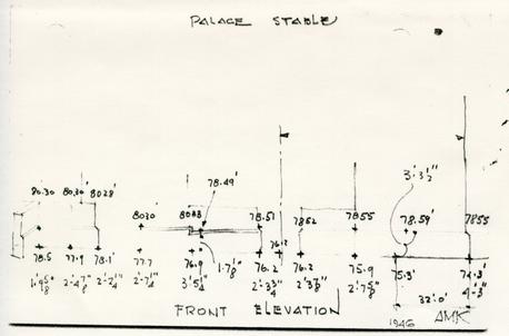 Palace Stable
Front Elevation
 424. The Stables in the East Wing
from Tippings - English Houses period
IV - vol. II - 1699-1736
Seaton Del[illegible] - 1718-28
Blueprint - oversized image - digital version unavailable